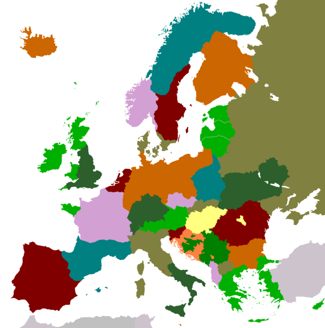
![[alternate Europe’s map]](EuropaAlternativa.png)
What would have happened if Simon de Montfort had failed and the Crown of Aragon had continued its northern expansion? What would have happened if the Castilian and Portuguese counties hadn’t survived? What if the Sami people had had their own country? Or if the Austrians had avoided being robbed Tyrol by the Italians? Or if Bavaria had refused to be a part of the German Empire during the XIX century? Or if ...? When reading history, there are many occasions where one asks himself questions like this and speculates about the changes those would bring to a political map.
For years, I’ve accumulated many of these ideas (some are mine, others I’ve picked up from other people’s comments, wether they were talking out of their asses or not), and I’ve decided to redraw the political map of Europe cramming as many of those as I could. Afterwards, I constructed all the necessary points of divergence to explain the existing differences.
It must be noted that the following map is historically impossible, that the ideas “written into” it can be even contradictory, and fluctuate beween the grounded historical demands (which could actually happen, should there be the political will) and outright crazy and inviable assertions, and, finally, that some points of divergence are better constructed than others (because I know some areas/ages of European history better than others). Do not forget this is a simple theoretical exercise, and I don’t advocate or support any of the ideas present here (although I do like some of them).
Note: when mousing over the map, the image will be replaced with a map of current Europe; clicking on it will bring a higher resolution version of this alternate Europe.
This alternate Europe differs from the real one due to the following changes:
English expansionism made the different neighboring kingdoms and fiefdoms form a military alliance to stop it; as centuries passed, the Celtic League (formed by Scotland, Ireland, Man, Wales, Kernow and Britain) has become a cohesive federation, considered for many intents and purposes to be a single nation (although Britain is somewhat isolated and its main peril is France, not England). It’s one of the three West Catholic Countries, so the other two (Leon and the Pyrenaic Kingdom) are its natural allies.
The Kingdoms of Portugal and Castille were unable to remain independent for long, and ended up reabsorbed by Leon, the hegemonic local kingdom. Since the early XIII century, this was the only one in charge of the Reconquista (as Aragon was focused on its northward expansion) and ended up occupying the rest of the Iberian Peninsula.
Occitania suffered dearly the Albigensian Crusade and French abuses. When Peter II of Aragon annihilated Simon de Montfort, his victory and popularity allowed him to expand his transpyrenaic lands, keeping in check French expansionism. The Pyrenaic Kingdom was formed by uniting into a single entity the Crown of Aragon, the Kingdom of Navarre (handed over to King James I after Sancho VII died without a heir, as agreed by the Treaty of Tudela) and almost all of the lands that formed Occitania.
Since the late XIV century, relations with the neighboring Leon are optimal, as the (progressively fewer) frictions between the governments of Toledo and Figueres are quickly mediated and solved by the Peñíscola Pope; it goes without saying that both countries are close allies.
The attempt to end the Western Schism took an unexpected turn: the Council of Constance deposed John XXII, Gregory XII and Benedict XIII (who had refused to acknowledge the council and therefore rebuffed any of its decisions); at first, this was accepted by everybody, but the election of Celestine VI, German Emperor Sigismund’s puppet, was rejected by the leonese, navarre and aragonese. After their demands went unheard, the iberian kingdoms switched their allegiance back to Benedict XIII; he quickly excommunicated Rome and moved the papal residency from Avignon to Peñíscola, where he could be better protected. A few weeks later, during a new war against England, loyal to Rome, all the kingdoms in the Celtic League also swore allegiance to Peñíscola.
The Peñíscola Papal State corresponds to the homonym city, ceded to this effect by Aragon in 1420. Today, the defense of this city‑state is jointly held by Leon and the Pyrenaic Kingdom.
Up to the present, relations with the Roman Catholic Church are cold and tense (on the other hand, relations with the Orthodox Church are much warmer, although they’re inevitably distant); Occidental Catholic countries suffered discrimination and isolation from Central Europe, but this was compensated by the 1481 discovery of the West Indies (the Neoiberian continent), carved up between leonese, celts and pyrenaics (which, in spite of being more of a mediterranean country, were able to take advantage of the opportunities opened up by their atlantic allies). Currently, West Catholics worldwide outnumber Roman Catholics.
Wars in Scandinavia never reached any conclusive results, because neither Denmark, Norway nor Sweden had any distinct advantage over the others. Sweden never conquered Botuslän, Halland, Scania and Bornholm, although it did manage to avoid a union between Denmark and Norway.
Further north, the Sami organized themselves as a nation, keeping all their lands and slightly expanding them. Their alliance with their finn cousins allowed the latter to form a stronger country, that kept both Sweden and Russia in line, managing at the same time to retain all of Karelia.
In 1860, Switzerland passed a law forbiding its citizens to serve as mercenaries abroad, but the Sicilian ambassador skillfuly brokered a deal with the government, creating an exception for his kingdom. When Garibaldi first attacked Sicily, he was defeated and killed. The later events in the north and the difficult conquest of the Roman Papal States postponed italian ambitions in the south; finally, Italy was forced to give up in 1880 its alleged rights over Sicily, as the latter had signed a military alliance with the Pyrenaic Kingdom.
Although at first the Bavarian king supported the german unification process, he was worried about the cultural and religious differences between the protestant north and the roman catholic south. Finally, after extremely hard negotiations between Ludwig II, Wilhem I and Franz Joseph I, it was agreed in 1871 to reduce the scope of the Kleindeutsche Lösung, creating two new german states: Germany (sometimes called North Germany), led by Prussia, and Bavaria‑Württemberg (nowadays known as Bavaria), formed by the southern german states. Luxembourg, constantly threatened by France, ended up joining Germany.
During the years immediately after the creation of the Two Germanies, an extremely shrewd propaganda campaign managed to convince most Swiss Germans that a union with Bavaria would be a good thing, so most German cantons joined it. After this abandonment, the Helvetic Confederation was dissolved; French cantons joined France, Italian cantons were annexed by Italy and the remaining German cantons (Graubünden, Saint Gallen, Appenzell Innerrhoden and Appenzell Ausserrhoden) along with the Romansh areas joined Austria (the latter ones actually feared for their language and cultural identity if they became part of Italy). Liechtenstein, now entirely surrounded by Austria, accepted the inevitable annexation some time later.
After surviving two murder attempts in a single day, Archduke Franz Ferdinand understood that the Austro‑Hungarian Empire wasn’t viable the way it was organized. After ascending to the throne in 1916, he quickly adopted Aurel Popovici’s proposal of transforming the empire into a federation of monoethnic states (the “United States of Greater Austria”), and implemented it, disregarding the Hungarian’s resistance and the imperial court’s reluctance, which feared the empire would break apart. Indeed, said federation had a short life and was soon dissolved; some of its members are still independent states, while the others joined other countries.
Franz Ferdinand paid a steep price for the empire’s dismemberment: at first he was the king of each state within the federation, but in less than a year he had lost all but four titles (king of Austria, Hungary, Bohemia and Slovakia). Romania and Transylvania’s unification led to a revolt in Hungary, which ended with the creation of the Hungarian Republic in 1923. This was used as an excuse to also depose Franz Ferdinand in Austria, who was replaced by his nephew Karl I; on the other hand, Bohemia and Slovakia kept their loyalty; Franz Ferdinand moved to Prague and ruled as king of both countries in personal union until his death in 1935.
Even today, Franz Ferdinand is despised in Austria and Hungary, as they believe his reforms were too radical and escaped his control, destroying the empire and decimating Hungary. On the other hand, in the neighboring slavic countries and in Romania, he’s widely respected, as they consider he solved a serious problem that could have ended in a huge bloodbath, and he can’t be held responsible for the skirmishes and little wars in the years following the partition.
In 1916, Greece attacked the Ottoman Empire to finish liberating Greek‑populated lands; they counted, once again, with Leon’s unrestrained military support, where this war was known as the “Final Reconquista Campaign in Europe”. The war ended with a strong Greco‑Leonese victory; after its defeat, the Ottoman Empire fell into civil war, and several oppresed ethnic groups (Arabs, Armenians, etcetera) took advantage of it to declare independence; Greece also exploited this situation to push the border even further east, to compensate—from their point of view— having had to give up their claims over territories such as Pontus and parts of Cappadocia (provinces that were too far away for an effective military occupation) and most of Western Thrace (which was under dispute with Bulgaria, and ended up being divided between the two countries). Nowadays, the Turkish Republic only spans part of the Anatolian Peninsula.
Proof of the Greek’s gratitude towards their allies is that in 1930 they renamed the city and province of Çanakkale; instead of reinstating the old name for the area (Dardanellia), they chose Lion (“Λιοντάρι” in Greek, after “León”). New symbols for the place where chosen as well, mixing the colors of the Greek flag with Leon’s coat of arms: the new coat of arms is blazoned as “Azure, four bars argent [the Greek flag’s colors], a lion rampant purpure, armed and langued gules [taken straight from Leon’s coat of arms, minus the crown].”), design that is also used on the new provincial flag.
During the Greek‑Ottoman war, at a particular moment where it seemed Bulgaria would attack Greece (due to their dispute over Western Thrace), Albania’s Prime Minister made the mistake of making grandstanding declarations, threatening to enter the war on the Ottoman Empire’s side... just one day before numerous Leonese reinforcements reached Greece. General Gregorio Pintos, the commanding officer, decided (without consulting with anyone) to invade Albania from the south; in just five days he had taken almost all of Northern Epirus, thanks to the surprise factor in his initial attack, to the small reaction capability of the Albanese military forces... and to the overjoyed cooperation of the local Greek population, who until then had been trying, unsuccessfully, to be part of Greece and not Albania.
During the two weeks following the invasion, General Pintos expelled the local Albanese population, who had to take refuge on the other side of the new border, and installed a provisional government for Northern Epirus, composed exclusively by Greek residents. Once the zone was secured, he left one fourth of his forces to protect it from a potential counterattack and travelled with the rest to Thessaloniki. Once there, the Greek military high command tried to reprehend General Pintos for his reckless actions, but he defended himself stating he had followed his orders (disembark his forces in Igoumenitsa and take them to Thessaloniki) and he had simply taken a scenic route. Since his lightning campaign had scared the Bulgarians back to the negotiating table, nothing happened to the general.
Meanwhile, this embarrassing defeat forced the fall of the Albanese government and the collapse of the Principality of Albania. By the time the Republic of Albania had risen, the loss of Northern Epirus was a fait accompli: there were almost no Albanese left there, and the remaining population had decided, by acclamation, to become a part of Greece; the new Albanese government had no choice but to sign in 1921 a peace treaty with Greece and Leon that formally accepted the state of things.
The trauma this... skirmish... produced in the Albanese population was so bad that even today, all of the zoos in the country refuse to keep lions (as well as Neoiberian big cats: cougars and jaguars).
The continuous social upheaval in Russia led to a civil war in 1918. Due to the central government’s weakness, Estonia, Latvia, Lithuania, Poland, Ukraine and Byelorussia became independent (although the latter one rejoined soon afterwards).
Fully aware that Russia would soon be knocking at their doors, Estonia, Latvia and Lithuania formed the Baltic Federation. They’re currently under North Germany’s sphere of influence, something that has made German‑Russian relations rather difficult; this has had the side effect of allowing Poland to keep existing, filling the role of a buffer state.
During the ’80s, internal divisions in Yugoslavia became so pronounced that a civil war seemed unavoidable. However, during Holy Week in 1990 (which that year coincided in both Roman Catholic and Orthodox Churches) the main extremist leaders on each side (Milošević, Tuđman, Mladić, Gotovina, et cetera) were eliminated with selective assassinations. The surviving moderate politicians, frightened by this series of operations, were forced to negotiate a peaceful agreement. In the end, Yugoslavia split up in four:
Slovenian and Macedonian borders were well defined and (except for a change to allow the former better access to the sea in the Istrian Peninsula) did not pose any problems. On the other hand, the border between Serbia and Croatia took months of difficult negotiations, but in the end an agreement was reached where both parties were reasonably unhappy.
Until this day, it’s unknown who was behind the “Bloody Holy Week” murders, although it’s safe to assume it was a group of high officials in the Yugoslavian Army, who decided to avoid a war by any means necessary. The only captured killer, a Serbian called Mirko Princip, commited suicide before he could be interrogated.
In Ukraine, disputes in the result of the 2004 presidential election ended up in a civil war that split the country in two: the pro‑rusian southeastern half was annexed by Russia, while the northwestern segment (pro Central Europe) kept its independence; a few weeks after the war, it changed its name to Rutenia to accentuate its distance from Russia.
After almost two centuries of indifferent cohabitation, Walloons and Flemish reached an agreement in 2007 to peacefully split up. Wallonia approved joining France in a plebiscite, while Flanders joined Netherlands immediately.
Genoa’s centuries‑long control over Corsica was always tenuous. Italian unification in the XIX century softened tensions, but those increased again in the early XX century, resulting in the rise of several independence movements in the island; in november 1942 a plebiscite was held, where independence was very narrowly approved.
The young Corsican Republic’s state apparatus was quickly coopted by local mafias, establishing a virtually dictatorial government; in 1960, Italy took heed of public clamor and invaded the island, imposing direct control. This status ended in 1978, when the Corsican Republic was reinstated, now as an Italian protectorate; this was a compromise solution that satisfied the corsican people, who, although did not want the island to be just another Italian region, now viewed full independence unfavorably.
Some of the borders aren’t perfectly drawn (for example, Germany’s eastern one and the frontier between Wales and England); this is due to my limited skills as a draftsman and to the fact that I used rudimentary tools. An expert will probably be able to redraw this map in a better way (and in less time).
I based the map on a preexisting one, extracted from Wikipedia; it’s available at http://commons.wikimedia.org/wiki/File:BlankEurope.png. This image is subject to the GFDL, so my map (not so the remainder of the article) is also suject to it:
Copyright (c) 2009, 2011, 2013 Miguel Farah.
Permission is granted to copy, distribute and/or modify this document under the terms of the GNU Free Documentation
License, Version 1.3 or any later version published by the Free Software Foundation; with no Invariant Sections, no
Front‑Cover Texts, and no Back‑Cover Texts. A copy of the license is included in the section entitled
“GNU Free Documentation License”.
1.0, 05/07/2009: initial version. The map for this version is available as EuropaAlternativa_v10.png (original size) and EuropaAlternativa_640_v10.png (reduced size).
1.1, 13/06/2011: added the Corsica entry. To better distinguish both Papal cities (Rome and Peñíscola) in the map, they now appear in black instead of red, and Leon’s color was changed from dark red to orange. In a similar fashion, Malta now appears dark red instead of orange to bring it out. For strictly aesthetical reasons, the garish pink color of France, Norway, Bohemia and Albania was replaced by a much better looking blue color. The map for this version is available as EuropaAlternativa_v11.png (original size) and EuropaAlternativa_640_v11.png (reduced size).
1.2, 28/12/2013: rewrote the entry about the 1916 Greek‑Ottoman war, adding more information and including the Albanese loss of Northern Epirus.
Return to Miguel Farah's personal website.
[ESPAÑOL] — [ENGLISH]